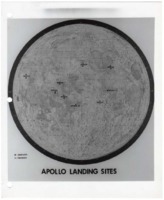
The map shows landing locations on the moon's surface, including proposed landing sites of the cancelled Apollo 18 and Apollo 19 missions. This map was created as part of the Lunar Roving Vehicle (LRV) Project.
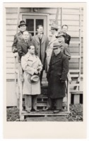
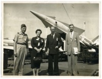
Tessmann is standing on the front row on the far left. Schulze is standing directly behind him. Tessmann and Schulze were both engineers who were relocated from Germany to the United States as part of Operation Paperclip after World War II.
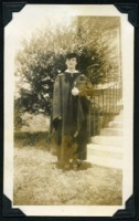
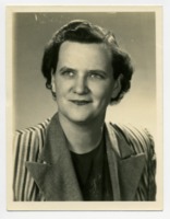
This photo was taken at the time of Roberts' doctoral graduation from the University of Alabama in Tuscaloosa, Alabama. She was the first woman to receive a Ph.D. in history from the University of Alabama. On either side of her are Howard C. Elliot, Jr., Ph.D. in biochemistry, and Elmer Dean Calloway, Ph.D. in chemistry.
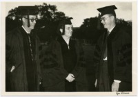
Photo from the Huntsville Times. The photo was taken for an article about the honorary doctor of humane letters that Roberts received from UAH on December 12, 1993.
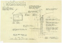
The drawings include plans for a building a well in the sidewalk with a glass top for viewing the "old handmade brick walk" underneath the current sidewalk. In one of the notes, architect Harvie P. Jones notes that the historic sidewalk probably dates from the early to mid-nineteenth century "based on its depth of approximately 10" below the present walk." The well is located in front of 205 East Side Square. It was restored in 2018.
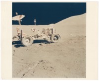
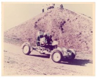
This photo shows the LRV on the moon at the Hadley-Appenine mountain range landing site during the Apollo 15 mission. Developed by Marshall Space Flight Center and built by Boeing, the LRV was an electric vehicle used to explore the Moon's surface during the Apollo 15, 16, and 17 missions.
Developed by Marshall Space Flight Center and built by Boeing, the LRV was an electric vehicle used to explore the Moon's surface during the Apollo 15, 16, and 17 missions.
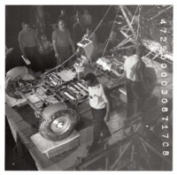
Developed by Marshall Space Flight Center and built by Boeing, the LRV was an electric vehicle used to explore the Moon's surface during the Apollo 15, 16, and 17 missions.
The photos show scenes from the sesquicentennial festivities in and around the square, including people dressed in early nineteenth century attire, storefronts, and street decorations.
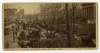
The photo shows the north side of courthouse square looking east in downtown Huntsville. The Madison County Courthouse can be seen at the right of the photo.
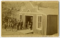
The photo shows the owner, Henry Fuller, with his family outside the cave entrance. Fuller purchased the cave in 1888 and developed it into an underground dance hall and bar. The cave is near current-day Pulaski Pike in Huntsville.